Posts

Showing posts from January, 2014

Bujang Valley Pathways -2

Image
The pathways between the East and West coast of the peninsular ,from the Bujang Valley are clearer in this enhancement. A path from Penang to Sungai Patani  ,and then to Yala, navigating a narrow strip of higher ground, seems evident.

Bujang Valley -Pathways

Image
Dear Friends I was alerted to the possible existence of an ancient trade route that may have connected the Merbok and Patani rivers. While routes of type may no longer be visible to the naked eye, and on site, an enhanced terrain image can highlight pathways that have long been hidden by sediment and vegetation. The image below is an attempt to make these pathways more visible, and as one can see , there are in fact formations in the central ranges  connecting a number of rivers that flow east and west.

Bujang Valley -More Views From The Sky

Image
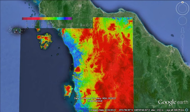
T This image is another enhancement of the satellite image of the Bujang Valley and surrounding areas in Northern Malaysia. This image has been enhanced such that viewers can more clearly identify the valleys, rivers and streams that come down into the valley from the central ranges. Could it have been possible for the early   inhabitants of the  Valley to yo have traveled overland to the East Coast, thus creating a state or sovereignty that extended across the peninsula,from the west to east coasts? Or could they have, from the Valley, traded with Chinese, Indo-Chinese,and other East Asians who could have landed their goods at various points on the East Coast? I look forward to your comments.